
By Alan J. Bartels
On the edge of the Nebraska frontier 150 years ago, Native Americans with ancient ties to the Sandhills were destined to meet more recent colonizers in a bloody skirmish with battle lines etched into the grains of a bare sand blowout.
In April 1876, US Army soldiers assigned to Fort Hartsuff – near the edge of the Nebraska Sandhills and the present day village of Elyria – were about to make their own chapter in the annuls of American military history.
Post on the North Fork of the Loup River was established after trapper Marion Littlefield was killed by Sioux braves north of Burwell, Nebraska, near Pebble Creek, in January 1874. Months later, the post was later renamed Fort Hartsuff, in honor of Major General George L. Hartsuff, who served with distinction during the American Civil War, and in the mid-1850s fighting the Seminole Tribe in Florida. The buildings at Fort Hartsuff were constructed using a cement/grout mixture that incorporated local sand.
Fort Hartsuff’s soldiers were only ever involved in one battle.
Accounts vary as to what ignited the altercation known today as the Battle of the Blowout. An authoritative description by historian Colleen Switzer in The Settlement of Loup and Blaine Counties reveals that all it took was for a band of Sioux to be seen near Jones Canyon (northeast of present day Burwell) to elevate concern among the local settlers.
Other trite accounts claim that the Indians had been attempting to steal from the white residents in the area. With their lands taken through force, broken promises, and flimsy treaties; their buffalo all but exterminated, and their culture teetering on the edge of extinction – if they were attempting to steal – it was likely a matter of personal survival. It’s not a stretch for this writer to imagine that similar straights could push just about anyone to similar actions.
A group of settlers and trappers began the chase.
Most historical accounts also note that three prospectors enroute to the Black Hills detoured from their dreams of striking it rich and made it their business to help take up the trail of the fleeing Indians over hills of foreboding sand. Fearing for their lives and outnumbered, those Sioux braves took up defensive positions in a large blowout – a wind-sculpted depression in the coarse sand that was nearly void of vegetation. While the Sioux were pinned down, one of the white men was sent to Fort Hartsuff for reinforcements, a straight-line distance of approximately 20 miles over dunes, through meadows, and across Dry Creek.
After the detachment arrived, its commander Lieutenant Charles Heyl, wasted little time in leading his men toward the blowout.
Sergeant William Dougherty crested a hill and was shot and killed. One of the Indians also lost his life in the exchange, and like Dougherty, left his lifeblood in the sand. The soldiers retreated and guards were posted as the sun arched toward the western horizon. In the inky black of the Sandhills night, the surviving Indians escaped.
Dougherty was buried with honors at Fort Hartsuff Cemetery. The US Army closed Fort Hartsuff in 1881, and Dougherty’s remains were re-interred at Fort McPherson National Cemetery near present day Maxwell, Nebraska.
More of a skirmish than a full-fledged battle, what has become known as the Battle of the Blowout warrants barely a footnote when compared to the widespread death and devastation that occurred in the era widely known as the Plains Indian Wars.
Today, tourists visit Fort Hartsuff State Historical Park to explore the grounds and nine original buildings and observe re-enactors during living history events.
As part of my research on the Battle of the Blowout, I tracked down a local historian who had attempted to locate the original battle site. Over the phone, he gave me a general description of where he thought the battle took place, based on stories heard decades earlier, but the man declined to show me the location. Not to keep the location secret. No, he declined because of mobility issues due to old age. “If you need a picture of the blowout, just take a picture of any old Sandhills blowout,” he told me. “That’ll do.”
No, that wouldn’t do for me.
I asked for more details but the man was done talking.
The description he had given me was vague, perhaps intentionally, but he indicated that the site was north of where Dry Creek enters Calamus Reservoir, and east of the road.
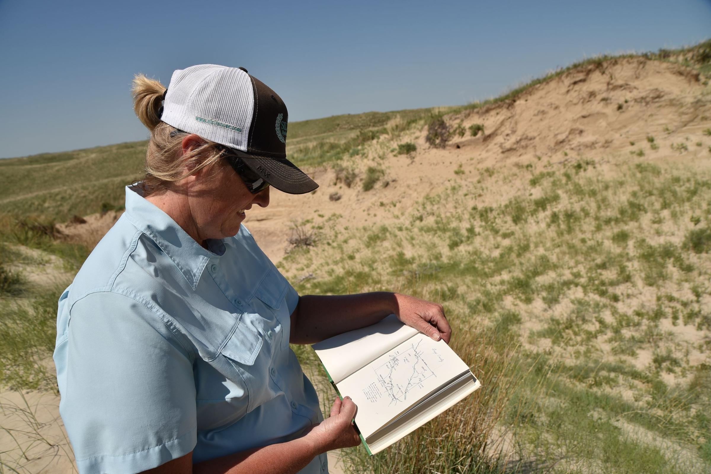
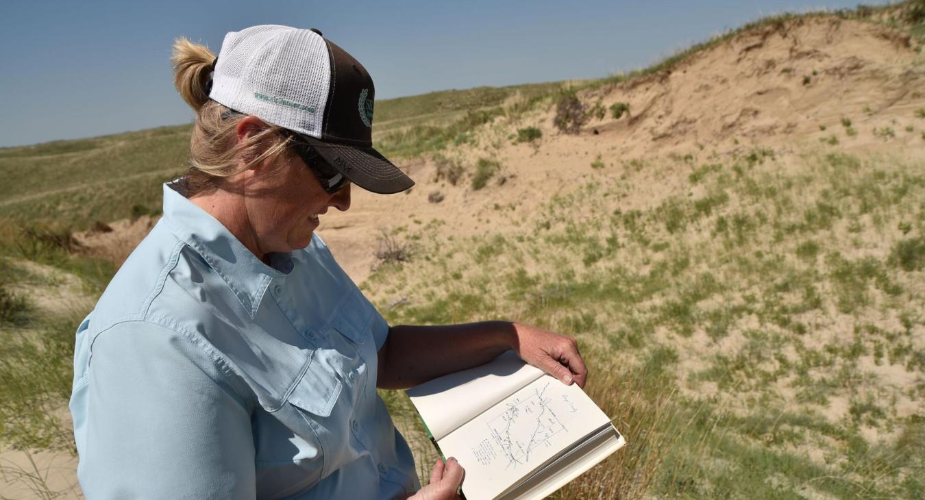
I’d been in that area before, so I contacted my friend Sarah Sortum, who lives in the area, and asked if she could get me access to that property. She did some checking for me, but imagine her surprise when she uncovered a map hand drawn by her grandmother – historian Colleen Switzer – decades earlier. In Switzer’s careful handwriting the map was clearly marked with a circled letter X and the words “Battle of the Blowout.” Even more surprising was that due to a land acquisition after completion of Calamus Reservoir, the historic spot shown on the map was now on her family’s land.
A couple weeks later, Sortum met me at a predetermined location near Dry Creek Road. I loaded my camera equipment onto her side-by-side and quickly headed off-road. Wildflowers were blooming across a blanket of lush green, and Sandhills meadows were flush with standing, life-giving water. A chorus of western meadowlarks, sandpipers, and other songsters called out from the grass and from atop fenceposts. Cows chewed their cud. Off in the distance, a mama cow bawled for her calf.
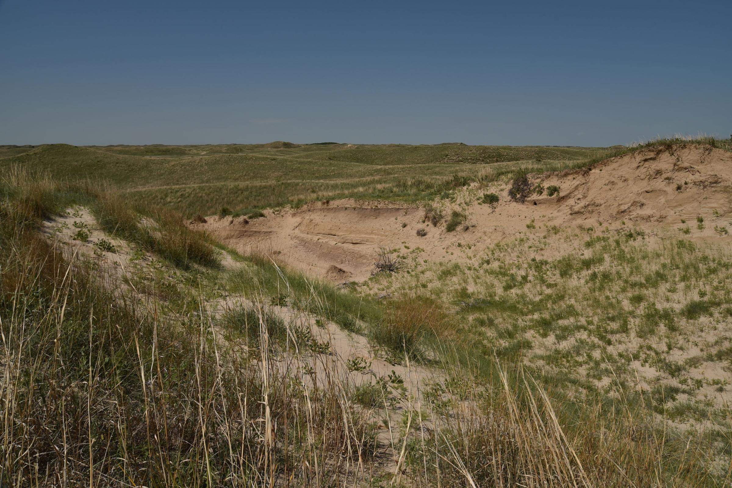
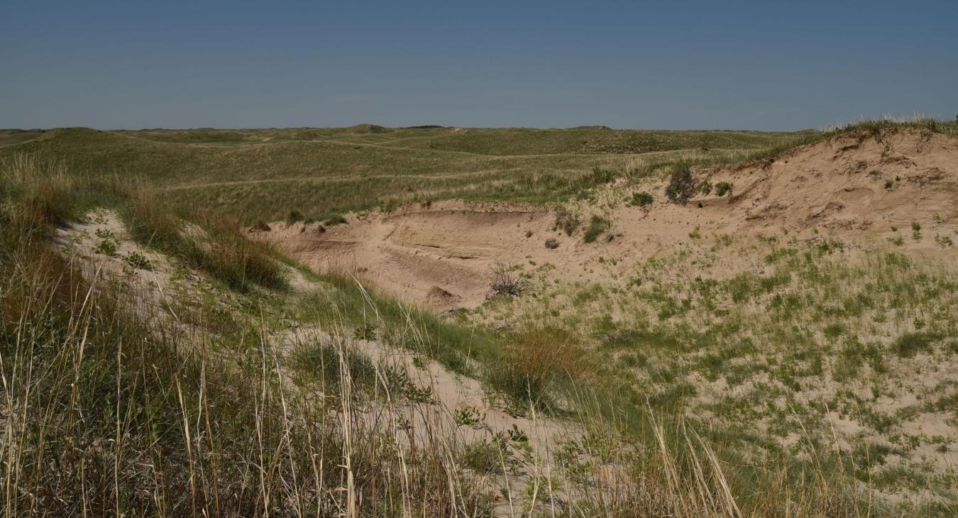
After navigating valley after valley, and sandy ridge after sandy, grass-covered ridge – while checking Grandma’s map every quarter mile or so, a huge sandy chasm opened up like God had yanked a handful of Sandhills prairie from the sandy earth. I’d seen larger blowouts, but not one with such large size and extreme geography. Having some military experience myself, I could immediately see how the Native Americans involved in the Battle of the Blowout could have used the sharp upsweep of the blowout’s eastern rim as a defensive position.
Of course, the land has changed in the 150 years since the battle occurred. But judging it with Army eyes strengthened during my time in another sandy area – the windswept deserts of southwest Asia during Desert Shield/Desert Storm, I didn’t see a safe vantage point from which the soldiers could aim toward their targets without exposing themselves to enemy fire. I wondered where Dougherty was standing when he was hit; and tried to imagine from which part of this sandy grand canyon did the fleeing Lakota men make their desperate, hopeful escape and head out across the Sandhills.
Had Sarah and I discovered the blowout where a relatively small military engagement during Nebraska’s first decade of statehood left a large sandy footprint in the history and culture of this part of the Nebraska Sandhills? We didn’t find any bullets, bits of clothing, or other signs of mankind in that sandy bowl near the Loup County and Garfield County line. If anything was ever left there, time and wind-driven shifting sands obscured it from prying eyes long ago.
No matter. The people who make their living on this land keep its history alive. And on a Loup County cattle ranch within walking distance of Dry Creek, one important part of our nation’s 250-year history lies within the very grains of the Nebraska Sandhills.
Alan J. Bartels is a US Army veteran who served with the 2nd Armored Division during Desert Shield/Desert Storm. His latest book, Secret Nebraska Sandhills: A Guide to the Weird, Wonderful, and Obscure, was released in March 2026.
The author uses “Indian,” “Indians,” and “Sioux” to reflect common usage at the time of this historic incident.